北林学子包揽2018第55届IFLA学生景观设计竞赛全部奖项
2018年7月18日上午9时(新加坡时间),2018第55届IFLA世界大会于新加坡金沙湾国际会展中心盛大开幕。此次大会由国际风景园林师联合会(IFLA)主办,由新加坡风景园林师学会(SILA)承办。本届大会的主题是:Biophilic City, Smart Nation and Future Resilience。
2018IFLA世界大会学生设计竞赛获奖结果揭晓。历届IFLA世界大会的一项重要活动是学生设计竞赛。2018IFLA世界大会学生设计竞赛将致力于展示世界范围内具有最高水准的风景园林教育成就。北林园林学子包揽学生设计竞赛全部奖项。
学生设计竞赛
1st Prize
Group Han Prize for Landscape Architecture
“冰”与“火”之歌
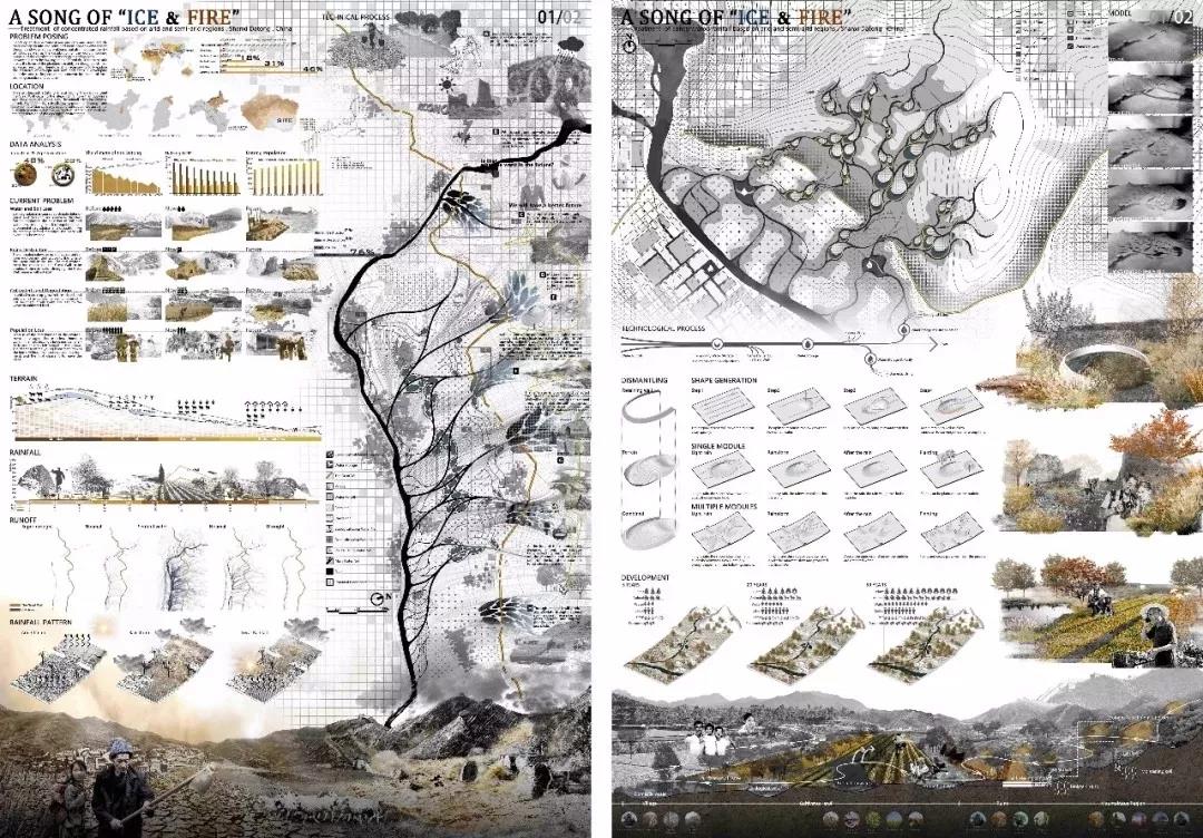
A SONG OF "ICE & FIRE"——Treatment of concentrated rainfall based on arid and semi-arid regions, Shanxi Datong, China
作品题目:“冰”与“火”之歌
作者:周超,李爽,王宏达,赵可极,王亚迪
指导教师:冯潇,郑小东,段威
学校:北京林业大学
Project Title:A SONG OF "ICE & FIRE"——Treatment of concentrated rainfall based on arid and semi-arid regions, Shanxi Datong, China
Author(s): Chao Zhou , Shuang Li , Hongda Wang ,Keji Zhao, Yadi Wang
Adviser(s): Xiao Feng, Xiaodong Zheng, Wei Duan
Institution: Beijing Forestry University
设计解读
该项目位于中国山西干旱半干旱地区,由于人们主要关注当地干旱缺水的问题,而忽视洪水发生的风险,因此,当干旱的土地遭遇集中降雨时,农田、村庄,包括古长城的遗址,都将被严重侵蚀。干旱的气候、集中的降雨和严重的水土流失造成了当地生态环境的恶性循环。 水灾与干旱的冲突让我们联想到“冰与火之歌”的主题立意,希望通过我们的设计能解决场地的冲突,谱出一首生态之歌。
在极端旱涝气候的背景下,为了解决影响当地的集中降雨带来的问题,我们提出了3个对策:输导雨水、储蓄雨水和利用雨水。创新之处在于:
(1)在降雨期,雨水通过地表径流流入设计路径,流经生态集雨地形,减缓径流的同时削弱了对土壤的冲刷,防止了水土流失。此外,我们使用自愈性混凝土来治疗裂缝,防止长城的进一步破坏。
(2)低洼地区水池蓄水。 根据设计路线将降雨引入预先设计好的生态蓄水池,水池周围的植物,有效地减缓了雨水蒸发。
(3)在干旱期,收集的雨水用于农业灌溉和生活用水,有效地利用雨水。
通过雨水的输导、储蓄和再利用,最终,将给当地的生态、生产和生活带来积极的影响,实现生态的良性循环。
The project is located in arid and semi-arid regions of Shanxi, China. People are mainly concerned with the local drought and water shortages while ignoring the risk of flooding. Therefore, when arid soils encounter concentrated rainfall, farmlands and villages, including the remains of the ancient Great Wall, will be severely eroded. The arid climate, concentrated rainfall and severe soil erosion have caused a vicious circle of local ecological environment.
In the context of the extreme climate with drought and flood, in order to solve the concentrated rainfall that has a great impact on the local ecology and life, we propose 3 strategies: grooming, savings, and utilization of rainfall. The innovation lies in:
(1) During rainfall, runoff points to the design path. Along the runoff path, ecological catchment landforms are set to reduce soil erosion,and keep water and soil intact. In addition, we use self-healing concrete to heal cracks and prevent further destruction of the Great Wall.
(2) In the low-lying areas, reservoirs were set up, and the rainfall was introduced into them according to the designed route. In order to slow down the evaporation of rainwater, plants are planted around the pool.
(3) During the dry period, the collected rainwater is used for agricultural irrigation and domestic water, and rainwater is used effectively.
Ultimately, these strategies will bring positive benefits to the local ecology, production and life, to realize a virtuous circle of ecology.
2nd Prize
IFLA ZVI MILLER PRIZE
与河迹共生
Symbiosis with River Trace

作品题目:与河迹共生
作者:谭立,张梦晗,蒋鑫,李鑫,孙雪榕
指导教师:王向荣,林箐,吴丹子
学校:北京林业大学
Project Title:Symbiosis with River Trace
Author(s): TAN Li, ZHANG Menghan, JIANG Xin, LI Xin, SUN Xuerong
Adviser(s): WANG Xiangrong, LIN Qing, WU Danzi
Institution: Beijing Forestry University
设计解读
研究区域位于缅甸东吁古城旁的锡唐河流域。雨季,锡唐河带来的洪水常常给这片区域的农业生产以及居民的生活造成损失,周边的产业结构也相对单一。由于地形相对平缓,锡唐河在漫长的历史演变过程中不断改道,产生了大量由河流旧道形成的河迹湖(牛轭湖)。
我们期望利用河迹湖形成区域内的一个弹性结构,以应对这里的雨洪灾害,改善当地的产业结构并保护郊区的生态资源。该体系包括弹性的雨洪管理、复合的产业结构和可持续的生态服务三部分。
通过对历史河迹的研究,我们在河迹湖与锡唐河主河道之间构建了一个绿色渠网体系,从而将孤立的河迹湖转变为调蓄水体,缓解洪水的灾害,并在旱季为农田提供灌溉用水。在雨洪系统之上,我们尝试建立了一个农业和渔业的复合产业结构,在不同季节都能维持一个相对稳定的生产力。随着植被的修复和生长,这片区域的生态价值亦会逐渐增长,生态游览与古城文化将逐渐融为一个完整的体系,为城市和区域注入新的活力。
The site is located near the ancient city, Toungoo, Sittang River, Myanmar. Floods caused by river changes and rainfall during the rainy season are natural disasters with the highest frequency and widest impact in this area. At the same time, local industries are single and production capacity is low. The deterioration of the ecological environment has also exacerbated many existing problems.
The landscape resilience of our design is embodied in three aspects: resilient management of rainfall and flood, resilient development of social economy, and sustainable development of ecological service. We plan to construct a rainfall and flood storage system by using existing river trace lakes. Floods are guided into the Oxbow Lake to ease flood pressure during the rainy season. The water can be used for irrigation. The security of the land and people’s life will be ensured. In addition, fishery production can be developed. Discarded sawdust can be used for mushroom cultivation. In this way, the development of agriculture, forestry and fishery will be promoted in an integrated and coordinated manner. We also expect to provide a good habitat for animals and plants through wetland restoration and forest protection. It will form a recreational sightseeing line linking the Oxbow Lake and the ancient city. Our design evolves with natural processes and presents different responses in different period.
Finally, the ability of responding to disasters in this region will be improved, and a sustainable and green industrial structure will be formed.
3rd Prize
Stephen Caffyn Landscape Design Merit Award
蓝色屏障
Blue Barrier
作品题目:蓝色屏障
作者:葛韵宇,李婉仪,邵明,叶可陌,王宇泓
指导教师:李雄
学校:北京林业大学,美国弗吉尼亚大学
Project Title: Blue Barrier
Author(s): Ge Yunyu, Li Wanyi, Ye Kemo, Shao Ming, Wang Yuhong
Adviser(s): Li Xiong
Institution: Beijing Forestry University, University of Virginia

设计解读
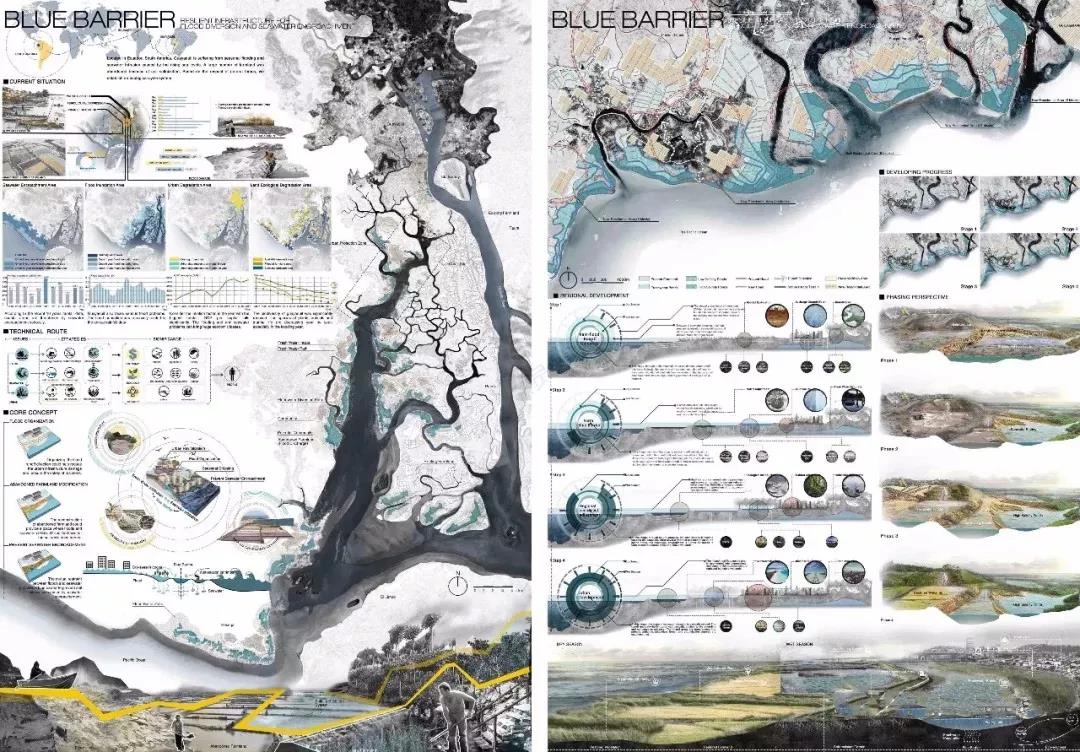
瓜亚基尔市位于南美洲厄瓜多尔,濒临太平洋瓜亚基尔湾,被称为“太平洋的滨海明珠”。近年来,瓜亚基尔正饱受海平面上升引发的海水倒灌和季节性洪水泛滥所带来的困扰——海水入侵带来的土地盐碱化,导致了大量农田被废弃;严重的洪水带来的城市雨洪安全,造成了严重的经济损失,滨海明珠逐渐暗淡。
我们的设计尊重自然的力量,建立了一个良好的自然循环系统——在现状因盐碱化严重而废弃的瓜亚基尔耕田基础上进行地形整理,形成若干层级的洼地,通过将城市雨洪引入废弃田地形成的洼地区域,对洪水径流进行存蓄利用的同时,利用瓜亚基尔高渗透性土壤特性,促使淡水径流在限定的洼地范围内下渗以形成渗透阻咸缓冲区,利用淡水海水间的浓度差有效的将海水入侵区域向内海侧推移,同时缓解海水入侵和城市雨洪两个问题。
本设计在解决城市问题的同时,提供了城市发展的可能——径流带来的上游泥沙在废弃田地沉积,形成次生林带和原生湿地,提供了城市扩张的空间余地;经过引导的海水在限定的洼地内汇集蒸发,增加土壤和水体的盐碱度,为白虾养殖业提供了天然良好的环境,以求促进瓜亚基尔经济进一步发展。
Located in Ecuador, South America, Guayaquil is known as the ‘coastal pearl of the Pacific Ocean’. Recent years, Guayaquil is suffering from seasonal flooding and seawater encroachment caused by the rising sea levels. A large number of farmland was abandoned because of soil salinization. The coastal pearl is gradually fading. The severe flooding not only has caused serious economic loss but also been a threat to urban security.
Based on the respect of natural forces, we establish an ecological cycle system. In the current site, due to the serious salinization and deserted farming in Guayaquil, the abandoned farmland was reorganized to form levels of depressions to store and purify floodwater. High-permeability soil encourages freshwater runoff to infiltrate through depressions to form an anti-salt barrier zone, the blue barrier. The difference of concentration between freshwater and seawater effectively prevent the seawater encroachment, which mitigates the problems of seawater encroachment and urban flooding at the same time.
Except for solving the urban problems, this design provides possibilities for the development of the city. The upstream sediments brought by runoff will accumulate in abandoned fields, forming secondary forest belts and native wetlands, providing room for urban expansion; The evaporation in the depressions increases the salinity of the soil and water, providing a natural environment for the white shrimp aquaculture industry which promote the further development of the Guayaquil economy.
版权声明:本文转载自微信公众号:北林园林资讯,版权归原作者所有,如有侵犯您的权益请及时联系,我们将第一时间删除。
投稿邮箱:contact@landscape.cn
项目咨询:18510568018(微信同号)


